Google Earth may be over 20 years old, but it's still learning new tricks – and its impressive Timelapses feature has just been upgraded with new imagery from the past two years.
Google Earth Timelapses, which are aerial flyovers that are stitched together from 24 million satellite photos taken over the past 37 years, first arrived in April 2021. But the interactive maps have now been refreshed with imagery from 2021 and 2022, which means you can watch how some parts of the world have changed this decade.
To take your Superman-style trip over your chosen city or region, head to Google Earth's Timelapse mode (opens in new tab) and type your destination into the search box. Timelapse will then run through a yearly aerial snapshot of how the land or buildings have changed from 1984 to last year.
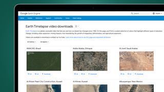
Not sure where to start? Google's also created standalone, downloadable videos of some particularly interesting regions that have changed a lot over the last 38 years, for better or worse. You can find these in the Google Earth Timelapse video downloads section (opens in new tab).
Some standouts include the building of a huge solar panel array in Granada, Spain (opens in new tab) and the arrival of some offshore wind farms in Middelgrunden, Denmark (opens in new tab). You can also watch the incredible pace of urban sprawl in Kuala Lumpur, Malaysia (opens in new tab), or search the world by themes like ‘changing forests' and ‘sources of energy' below the Timelapse mode's search box.
Naturally, the resolution of these timelapse maps isn't as high as the ones available in standard Google Earth, but they provide a pretty fascinating overview of how some regions have changed dramatically or, in the case of Kirov in Russia, slowly returned back to nature after humans abandoned their farmlands.
Flying through history
Google called Timelapses “the biggest update to Google Earth since 2017” when the feature launched in 2021. These updates make it a much more useful tool for anyone who wants to use it for education or simply a lunch-hour timesink.
National Geographic even used the Timelapses mode for a documentary called The Territory (opens in new tab), which follows the fight of indigenous people in the Brazilian rainforests against encroaching deforestation.
The reason why Google Earth is able to do timelapse as far back as the 1980s is thanks to open data from NASA and Landsat, which is the world's longest-running Earth observation program. The EU's Copernicus program has also helped thanks to its Sentinel satellites.
Google Earth isn't the only mapping tool that Google's been busy updating recently, either. It's also upgraded Maps with a new next-gen Street View feature called Immersive View currently rolling out on its desktop and mobile apps.
We're looking forward to using that for everything from vibe-checking holiday destinations to planning our photography trips. And if you didn't that was coming, we've also put together a further 10 things you didn't know Google Maps could do.


